JACOB VANVALKENBURGH (linked to Genealogies page)
The research here concerns the Jacob VanValkenburgh of New York State who married Chloe Hodges, daughter of Timothy and Miriam (see Hodges research). This page raises many questions; much more work is needed to confirm or refute some of this material, and corrections are welcome.
ORIGINS IN KINDERHOOK, NY
Jacob was likely of Kinderhook, as evidenced by his family's connection with Lieutenant Guysbert Sharp, of Kinderhook, and later, of Ernestown. Upon arrival in Canada in the fall of 1790, Jacob requested land: “Jacob VanValkenburgh, late of the County of Albany prays to be admitted as an Inhabitant & to have a lot of land assigned him in this district. He appears to be a young man of good character from the testimony of Lieut Sharp & his brother & of a family reputed friends to Government...” (1). For Guysbert Sharp (Guisburt, Gilbert, etc.) and his brother to both testify that Jacob’s family were friends of the British, the Sharps must have known the VanValkenburghs, yet Jacob had just arrived. This indicates the Sharps knew Jacob’s family before they left Kinderhook several years earlier.
Where in Kinderhook was Jacob from? An excerpt from a map showing a Guysbert Sharp's farm shows the location to be along the Kline Kill, which flows north from present-day Ghent to form the Kinderhook-Chatham boundary and then joins Kinderhook Creek a few kilometres east of the village of Kinderhook. All of this area was Kinderhook until 1795 when Chatham was created, and then in 1818 Ghent was formed to the south from parts of Kinderhook and Chatham (2).
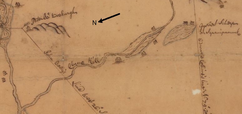 Guysbert Sharp's farm. Source: New York State Archives. New York (State). State Engineer and Surveyor. Survey maps of lands in New York State, ca. 1711-1913. Series A0273-78, Map #411.
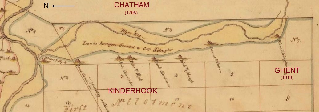
It is reasonable to assume Jacob would have lived in the same area as Guysbert, and there is supporting evidence. A transcription of a petition from this area in 1774 shows a Gilcox Sharp and three VanValkenburghs, including "Jacobie," grouped closely in the list of names (3). "Gilcox" is a presumed mistranscription. "Jacobie" is a diminutive for Jacob, perhaps indicating this was "Jacob the younger" (more on this below).
But does this map show the correct Guysbert Sharp? There were several of this name, including two loyalists in the United Empire Loyalist Association directory (4), both of Kinderhook. One loyalist was indicted in Mar 1780 and one in Apr 1780 (5). The one in Jacob's petition married Bautche VanValkenburgh in 1770, served as a lieutenant in Jessup's Loyal Rangers, arrived in Upper Canada in 1784, settled in Ernestown, and left Bautche as a widow in 1826. The other loyalist Guysbert was detained in New York and didn't arrive in Upper Canada until September 1790. He settled in Fredericksburgh. The men knew each other; the first Guysbert supported the second one in his petition (6).
The following information about the property of the earlier Guysbert emigrant is consistent with the map:
- comprised of 220 acres with 120 acres improved, according to Guysbert, his supporters (7), and the Commissioners of Forfeitures in Albany (8).
- straddled the boundary between Kinderhook and Chatham as it lay partly in both towns (9) in the year after Chatham was carved from Kinderhook (and well before Ghent was created as a separate town).
The farm was near one of Peter Vanalstine's properties (7) and three miles from Peter VanSchaik's residence (10). Attempts to find these two Peters' properties to test the proposed location of Guysbert's farm are ongoing. Deeds have been searched for relevant surnames without success so far.
The Commissioners of Forfeitures certified the sale of 120 acres of land forfeited by a "Guysbert Sharp the younger late of Kinderhook...at present in Canada" (8). As this document was dated before 1790, it refers to the first loyalist Guysbert to immigrate, the one who testified for Jacob's petition. Guysbert's birthdate is unknown, but his marriage in 1770 allows him to be younger than both the other Guysbert loyalist (b. 1743) (4) and other Guysberts in Albany County (b. 1821 and 1841 according to unverified online trees).
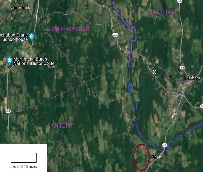 The red oval estimates the location of Guysbert Sharp's 220 acres at the boundary of Kinderhook and Chatham. Guysbert and Bautche married at the Vosburgh tavern, estimated location at the white X.
The satellite image attempts to place Guysbert's farm using the 1768 map shown earlier, which locates "Gysbert Scherp" at "Squampamuck" at the bend of the Kline Kill. Squampamuck is now Ghent (11), so it fits well with the proposed location at the village of Ghent on the satellite image.
Guysbert Sharp and Bautche VanValkenburgh were married on 5 Apr 1770 "in the town of Kinderhook at the tavern of John Vosburgh," according to James Wyngart, who was a guest at the wedding (12). The Vosburgh Tavern was located at a small burial ground (13) with "stones in field along boundary line, in back of oil co. bldg. on RT 203" (14). The boundary referred to is modern, probably the line between Chatham and Ghent, but since both towns were part of Kinderhook in 1790, Wyngart's statement was correct. The sources consulted indicate the Vosburg Tavern was owned by John in 1770, and later, evidently by Evert Vosburg.
The graves at the tavern site are all Clarks (13), a family reportedly having first names that also appear in Upper Canada, including Edward (15). An Edward Clark's land petition was dealt with at the same land board meeting as Jacob's on October 20, 1790 (1). (Edward's and Jacob's petitions were separated only by the one for John Sharp, presumably the brother of Guysbert that supported Jacob's claim, who was requesting additional lands beyond those already granted.) Like Jacob, Edward was known by the Sharps while in New York as they agreed with information in Edward's statement that he was a loyalist before arriving in Upper Canada (16).
EVIDENCE FOR JACOB'S KINDERHOOK RELATIVES
A deed from 1796 shows Guysbert's farm was confiscated due to his loyalty to the British during the American Revolution, and that by 1796 it was occupied by Bartholomew P VanValkenburgh.

Since Guysbert's wife was Bautche VanValkenburgh and his farm was occupied by Bartholmew VanValkenburgh, it's worth considering whether these VanValkenburghs were closely related to one another, and to Jacob as well. The extensive database of The National Association of the Van Valkenburgh Family (navvf.org) shows 72 VanValkenburgh men with first name Jacob (including Jacobus, i.e. James). After eliminating those who were not from Kinderhook, who married someone other than Chloe Hodges, who lived outside Canada after 1800, or who were born outside the years 1760 through 1775 (given that Jacob’s wife Chloe’s birthdate was about 1770, Jacob was a father in 1793, and that Jacob was described as “a young man” in 1790), there is only one candidate. This remaining Jacob, baptised 15 Jan 1769, was the son of Bartholomeus VanValkenburg (17).
Unverified online trees report this Jacob's father, Bartholomew (b. 1743), as the first cousin of Bautche (b. 1751). They were children of brothers Lambert (b. 1704) and Jacob (b. 1720) respectively, two sons of Bartholomeus (b. 1678). Further, there is another connection, though somewhat distant: this Jacob's baptism was witnessed by his maternal grandfather, Jacob Scherp (17), who was a first cousin to Guysbert's father according to the online trees. Having connections both to Bautche through his father and to Guysbert through his mother would support the notion that this is the Jacob who went to Upper Canada and did so because he had relatives there. These details do not prove our Jacob of interest was this Bartholomew's son, but it is a reasonable working hypothesis.
In Chloe’s 1800 land petition she describes herself as married to “Jacob Vanvolkenburgh Junior” (18). “Junior” in the early Dutch records either meant “son” or “the younger” according to the Genealogy of the Van Valkenburgh Family in America. If the contention above and online trees are correct, Jacob had two granduncles named Jacob VanValkenburgh. One (b. 1720) was his paternal grandfather's brother, and the other (bap. 1721) was married to his maternal grandfather's sister. It is unclear why Chloe would refer to her husband as she did unless they had recently lived near one of these elder Jacobs (which is possible, see below) or there was a long-standing tradition that he was known as such. Her reference to Jacob also lends support that "Jacobie" found earlier on the Chatham petition of 1774 is the correct one, if "ie" is used as the Dutch diminutive to signify "the younger."
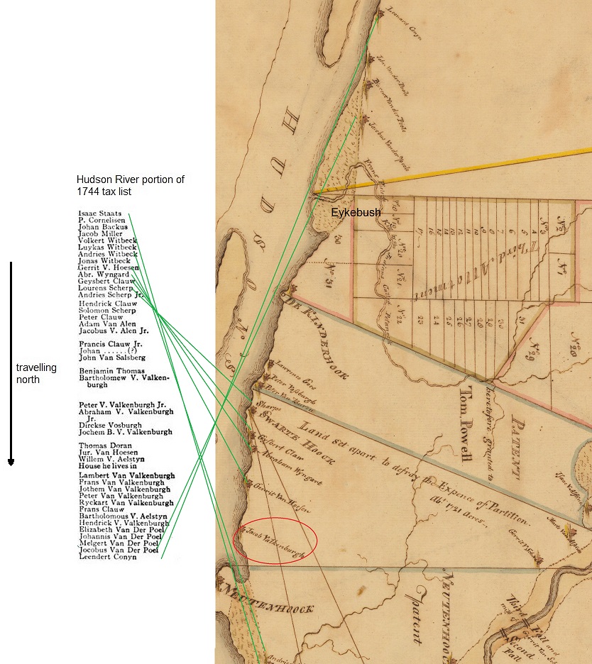
An existing transcript of a tax list from 1744 (19) and a Kinderhook Patent map from about 1768 (20) can be used in combination to approximate the location of many Kinderhook families. We find a Jacob Van Valkenburgh on the Hudson River about a mile from a Sharp family. To determine which Jacob VanValkenburgh this might be, we notice that his neighbours appear in sequence on the tax list, but he is omitted. This suggests that Jacob was likely single at the time of the tax list and still living with family but was a landowner about 20 years later when the map was created. A good candidate for this man is that maternal granduncle of Jacob who was baptised in 1721 and married about 1747. He was in Kinderhook at the time the map was made, and further, his neighbour a few houses north (“Sharpe” on the map; “Laurens Scherp” on the tax list) was this Jacob’s father-in-law according to the NAVVF site.
The tax list suggests the approximate location of a cluster of VanValkenburghs that are not marked on the map. Among them we find Bartholomew (b 1678) and three sons, all with separate households. A little farther along, we find Lambert (b 1672) with sons and grandsons. We can have some confidence in the reliability of the location of these unmarked VanValkenburghs because the will of Lambert’s grandson, Andries, mentions lands at Eykebush Creek [Mill Creek/Petanock Creek/Eichybush], which is what we would expect from the tax list.
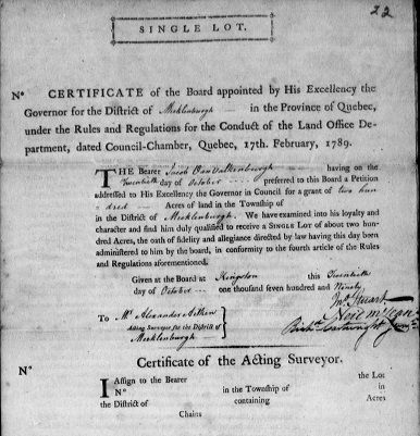
UPPER CANADA Jacob arrived in Upper Canada in 1790 (21), either directly from Kinderhook, or perhaps, since he was from "Albany County" rather than "Columbia County," from somewhere farther north (Kinderhook had been part of Columbia County since 1786). He petitioned for land in Eighth township while in Kingston (22). Augusta, Sidney, and Camden were all known as the 8th Township, but Augusta can be eliminated since Jacob petitioned for land in Mecklenburgh District, and Camden is also discounted as it was known as "Township No. 8" previous to the survey of Sidney in 1787. The petition was successful, and a Land Board Certificate was issued 20 Oct 1790 with no location specified by the Acting Surveyor, presumably because Jacob intended to leave for the United States and did not request the surveyor to complete the form at the time (23). Descendant Matt VanVolkenburg has pointed out that since Chloe's sister and her in-laws were already in Augusta Township, it is unlikely that Jacob would have requested Sidney as a settlement location if he had known Chloe at the time. We assume, therefore, that Jacob returned to the US and met Chloe there. |
|
RETURN TO NEW YORK
It seems Jacob returned about 1791 to the US, where he met Chloe Hodges, married her, and had son David baptised at Schuylerville in August 1793 (24). Why Jacob returned to New York, and why he went to Walloomsac (if, indeed, Chloe was still there -- see Hodges page), needs more investigation.
RETURN TO UPPER CANADA
The family then went back to Upper Canada and settled in Augusta near Chloe's brother Timothy, who had been there since the summer of 1793. Since David was baptised in New York five days after Chloe’s brother Timothy Hodges was in Augusta Township requesting land, it’s clear that Timothy went to Augusta first, and Chloe took Jacob there to settle, not later than the 1796 census. Chloe's family connection in Augusta would explain why Jacob didn’t return to Ernestown and settle there, even if he was related to Bautche VanValkenburgh.
The 5 Apr 1796 census shows the "Jacob VanVallenburg" household in Augusta Township: 1 man [Jacob], 1 woman [Chloe], 1 boy [David], 1 girl [Margaret], 4 in total (25). There are four documents that suggest that Jacob and family moved again, possibly back to New York:
1. Land certificate: In 1797, Jacob was again recommended for 200 acres of land (26), but as in 1790, no document has been found to show the recommendation was followed up on and located by the surveyor. This may mean, as in 1790, that Jacob was not in the province to request a location be assigned.
2. Augusta census: Jacob is missing from the 1798 census of Augusta while names near Jacob's in 1796 do appear in 1798. Property locations are known for some neighbours, but they do not help narrow down Jacob's location in Augusta (e.g. Thomas Shatford L25 C3, L30 C5; Godfrey Hanes L6 C5, L31 C8, L34 C2).
3. Murray census: Son David reported in 1842 that he had been in Canada for 42 years rather than the expected 46 or more years, so the family may have left Canada and returned in 1800, or David's statement may simply have been an approximation.
4. Michigan census: Son Timothy, born 1797, reported in 1860 and 1870 that he was born in New York (27).
Further, as implied earlier by Chloe's 1800 petition, she and Jacob Junior could have spent time with relatives in Kinderhook just prior to this. Regardless, the family was in Augusta for the 1801 census, where Jacob had two sons [David and Timothy] and two daughters [Margaret, unknown].
Information provided by descendants Wayne and Matt VanVolkenburg shows that Jacob had connections to Montague, Edwardsburgh, and Elizabethtown Townships. On 25 Jan 1802, Jacob and Chloe sold to Rice Honeywell L25 C6 Montague (28), land Chloe had been granted as a daughter of loyalist Timothy Hodges (29). In 1803, the family was enumerated in Edwardsburgh as 1 man [Jacob], 1 woman [Chloe], 2 boys [David, Timothy], and 2 girls [Margaret, unknown] (30). In 1812, Chloe was the head of the household in Elizabethtown and enumerated with 2 males, presumably sons Philander and Andrias, with David and Timothy (and possibly Jacob, see below) on duty with the militia (31). Chloe was at approximately L18 C1 Elizabethtown based on the locations of those listed adjacent in the census list.
WAR OF 1812
Author Winston Johnston records "John/Jacob VanVolkenburg" and "Jacob Wattenburg," both labourers born in the United States who enlisted at Montreal with the Glengarry Light Infantry and received a land grant in Upper Canada (32). The former enlisted on 1 Feb 1815 and was discharged 25 Mar 1815, and the latter served 13 May 1812 to 24 Mar 1815.
These may have been the same person due to the several identical details and because both surnames are listed on the fiat for service for Bathurst Township (image below). If not, it is clear that the recipient of the Bathurst land was the one who served three years with the Glengarry Light Infantry and was recorded as "Jacob Valtenbuck," native of New York (33).
There were two properties awarded for service. In 1816, we find: "A return of locations made by Alex McDonell Esq superintendent of locations for disbanded soldiers and emigrants...Township of Lancaster...Jacob Vottenburg, late Private Glengy Lt Infy, L14 C7 Lancaster" (34). This land is just east of Glen Nevis, Ontario, at the Quebec border. A private was to be allocated only 100 acres of land, suggesting the Bathurst and Lancaster lots were for two separate people. A complication, however, is that early enlisters were promised 200 acres, and it appears some may have received this double portion (35).
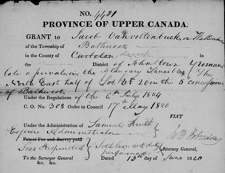 Fiat for land for service with the Glengarry Fencibles. Source: Ontario. Crown Lands Department. Military fiats (v. 109) bundle A4 - Z25, 1820-1821. FHL microfilm 008346055, image 601 <https://www.familysearch.org/ark:/61903/3:1:3Q9M-CSTB-GPWG?i=600&cat=283269>
Given that son David enlisted and served with the Glengarrys and Timothy is also listed as deserted, it is tempting to assign a Jacob who enlisted as their father, but this may not be the case:
- Johnston's entry for Jacob Wattenburg, the Jacob listed as serving for three years, gives his age as 18 (32), far too young to be our Jacob. The probability of a man born by 1770 serving in a non-commissioned capacity with the Fencibles was only 2.5%, as calculated from the known ages of 497 men.
- This Jacob sold his Bathurst property to James Freeman on 6 Jun 1832 (36), yet our Jacob reportedly died about 1828 (37).
- The Bathurst Jacob would have lived there prior to completing the terms of settlement on 2 May 1819 (38), and he was "of Bathurst" in 1820 (39) and still there in 1832 (40), yet it was Chloe's Jacob who was at L20 C7 Haldimand (41) "many years" prior to 1843 and who was already living at Murray before ca1828 (37).
- The Bathurst Jacob is listed after 1819 without family members as one adult male (42).
- These Jacobs enlisted in Montreal rather than Kingston, where David enlisted (32).
- In 1812, Chloe was enumerated as the head of the household, yet "in 1812 and early 1813 women and children of the Glengarry Light Infantry accompanied their husbands and father when quartered in Quebec City, Trois-Rivieres, Montreal, Prescott, Kingston and York" (43). If Jacob were away with the militia, there was a reasonable chance Chloe and children would have been with him.
The Bathurst patent was erroneously issued to John Cherriot (44), who was to receive the west half-lot adjacent to Jacob, but the error was corrected (45) after discussion with both parties (46).
FINAL YEARS
If our Jacob was not at Bathurst, he may have spent several years at L20 C7 Haldimand Township, where son David requested a patent as Jacob's son (47), and missed the early censuses, which appear to extend north only to about the fifth concession. He does not appear in the Augusta 1823 census, yet Chloe was in Augusta in 1824 (48). They may have lived together in Murray with Chloe returning to her relatives in Augusta by 1835 (49) after Jacob died.
SOURCES
(1) Library and Archives Canada. "Upper Canada Land Board Minutes and Records, 1765-1804," vol. 7, p. 204, Heritage Canadiana Microfilm reel C-14027, image 514-515, <https://heritage.canadiana.ca/view/oocihm.lac_reel_c14027/514>
(2) The Hudson Gazette. (1900). “Columbia County at the End of the Century: A Historical Record of Its Formation and Settlement, Its Resources, Its Institutions, Its Industries, and Its People.” p. 35 <https://books.google.ca/books?id=adM4AQAAMAAJ&source=gbs_navlinks_s>
(3) Ellis, Franklin, "History of Columbia County, New York," Internet archive (Online: 2008) [Originally published by Everts & Ensign, 1878], p. 284, <https://archive.org/details/historyofcolumbi00ever/page/284/mode/2up>
(4) United Empire Loyalists’ Association of Canada, “Directory of Loyalists,” accessed 2021 <http://www.uelac.org/Loyalist-Info/loyalist_list.php?letter=s>
(5) Ancestry.com. UK, American Loyalist Claims, 1776-1835 [database on-line]. Provo, UT, USA: Ancestry.com Operations, Inc., 2013. Original data: American Loyalist Claims, 1776–1835. AO 12–13, p. 70-71. The National Archives of the United Kingdom, Kew, Surrey, England. <https://www.ancestry.ca/imageviewer/collections/3712/images/43271_635001_0107-00168>
(6) Library and Archives Canada. (1811). Upper Canada Land Petition, RG1 L3 vol. 457, S11/187, LAC Microfilm Publication C-2812 image page 237 <https://www.collectionscanada.gc.ca/microform-digitization/006003-119.01-e.php?q2=29&q3=2616&sqn=237&tt=1238&PHPSESSID=rgi7t06a60or2jdheocn6v65f4>
(7) Ancestry.com. UK, American Loyalist Claims, 1776-1835 [database on-line]. Provo, UT, USA: Ancestry.com Operations, Inc., 2013. Original data: American Loyalist Claims, 1776–1835. AO 12–13, vol. 33, p. 128-130. The National Archives of the United Kingdom, Kew, Surrey, England. <https://www.ancestry.ca/imageviewer/collections/3712/images/40939_307352-00084>
(8) Ancestry.com. UK, American Loyalist Claims, 1776-1835 [database on-line]. Provo, UT, USA: Ancestry.com Operations, Inc., 2013. Original data: American Loyalist Claims, 1776–1835. AO 12–13, vol. 15, p. 333. The National Archives of the United Kingdom, Kew, Surrey, England. <https://www.ancestry.ca/imageviewer/collections/3712/images/40939_307172-00448>
(9) "United States, New York Land Records, 1630-1975," database with images, FamilySearch (https://www.familysearch.org/ark:/61903/3:1:3QS7-L9WQ-PZVW?i=354&cc=2078654&cat=245976), Columbia County Deeds, vol A, image 355
(10) Ancestry.com. UK, American Loyalist Claims, 1776-1835 [database on-line]. Provo, UT, USA: Ancestry.com Operations, Inc., 2013. Original data: American Loyalist Claims, 1776–1835. AO 12–13, vol. 83, p. 379. The National Archives of the United Kingdom, Kew, Surrey, England. <https://www.ancestry.ca/imageviewer/collections/3712/images/40939_307141-00402>
(11) Winchell, Debra, “Mohican Place Names,” in History’s Faces, <http://historysfaces.blogspot.com/p/mohican-place-names_8.html>
(12) Ancestry.com, “UK, Pension Applications For Widows and Family of Military Officers, 1776-1881,” p. 74, original data: War Office: Officers’ Birth Certificates, Wills and Personal Papers. WO 42/52–63, p. 38. Records created or inherited by the War Office, Armed Forces, Judge Advocate General, and related bodies. Kew, Surrey, England: The National Archives. <https://www.ancestry.ca/imageviewer/collections/3353/images/40943_1000052437-00177>
(13) Van Deusen, Robert T., “Some Columbia County (N.Y.) Graveyards,” in The New York Genealogical and Biographical Record, Internet archive (Online: 2011) [Originally published by New York Genealogical and Biographical Society, 1895, vol. 26, p. 119, <https://archive.org/details/newyorkgenealog26newy/page/118/mode/2up>
(14) KB, “Henry Clark,” Find a Grave, 2013, accessed Nov 2021, <https://www.findagrave.com/memorial/103180181/henry-clark>
(15) Cindy Freitag, “Roelof Clerk MRIN888,” Ancestry, accessed Nov 2021, <https://www.ancestry.ca/family-tree/person/tree/71686710/person/320024271710/facts>
(16) Library and Archives Canada. “Upper Canada Land Petitions (1763-1865),” microfilm C-1723, C12/184. <https://www.collectionscanada.gc.ca/microform-digitization/006003-119.01-e.php?q2=29&q3=2394&sqn=120&tt=1316&PHPSESSID=rgi7t06a60or2jdheocn6v65f4>
(17) Ancestry.com. U.S., Dutch Reformed Church Records in Selected States, 1639-1989 [database on-line]. Provo, UT, USA: Ancestry.com Operations, Inc., 2014. Original data: Dutch Reformed Church Records from New York and New Jersey. Holland Society of New York, New York, New York.<https://www.ancestry.ca/imageviewer/collections/6961/images/42037_647350_0290-00108?pId=110070>
(18) Library and Archives Canada. “Upper Canada Land Petitions (1763-1865),” microfilm C-2947 vol. 514 U-V Bundle 5/4 1800-1802, <https://www.collectionscanada.gc.ca/microform-digitization/006003-119.01-e.php?q2=29&q3=2647&sqn=233&tt=1306&PHPSESSID=rgi7t06a60or2jdheocn6v65f4>
(19) Collier, Edward A. (1914). A History of Old Kinderhook from Aboriginal Days to the Present Time, p. 109.
(20) New York State Archives. Map of the Kinderhook Patent, by Isaac Vrooman, State Engineer and Surveyor. Survey maps of lands in New York State, ca. 1711-1913. Series A0273-78, Map #889.
(21) Library and Archives Canada. Heir and Devisee Commission, reel H-1137, image 169 <https://heritage.canadiana.ca/view/oocihm.lac_reel_h1137/169?r=0&s=1>
(22) Library and Archives Canada. “Upper Canada Land Petitions (1763-1865),” microfilm C-2842 vol. 513 UV Bundle Misc/46, image 810. (see also “Upper Canada Land Books,” Land Book K 1819-1820, p. 415, microfilm C-103
(23) Library and Archives Canada. “Upper Canada Land Petitions (1763-1865),” microfilm C-2947 vol. 514 U-V Bundle 3/22, 1797, <https://www.collectionscanada.gc.ca/microform-digitization/006003-119.01-e.php?PHPSESSID=rgi7t06a60or2jdheocn6v65f4&sqn=67&q2=29&q3=2647&tt=1306>
(24) Schuylerville Reformed Protestant Dutch Church, “Register of baptisms,” accessed at Albany State Library, A974.748 fS39 oversize, p. 41
(25) Library and Archives Canada. "Return of the Inhabitants of the Township of Augusta, 5th April 1796," MG9 D8-1, Heritage Canadiana Microfilm C-1345, image 282, <https://heritage.canadiana.ca/view/oocihm.lac_reel_c1345/282?r=0&s=3>
(26) Library and Archives Canada. “Upper Canada Land Books,” Land Book C, p. 271, microfilm C-101, image 442; typed index at Sessional Papers: Vol 5, 1892, p. 7A-153 <https://parl.canadiana.ca/view/oocihm.9_08052_25_5/857?r=0&s=1>
(27) Ancestry.com. 1860 United States Federal Census [database on-line], Provo, UT, USA: Ancestry.com Operations, Inc., 2009. Images reproduced by FamilySearch. Census for Ovid, Branch, Michigan, p. 677, image 26
(28) Leeds County (Ontario) Registrar of Deeds, “Leeds County Deeds,” vol. B, p. 17, database with images, FamilySearch (https://www.familysearch.org/ark:/61903/3:1:3Q9M-CSVG-DZ6X?i=75&cat=484032), microfilm 008129913, image 76
(29) Ontario Crown Lands Department. (1801). Montague Township papers, RG1 C-IV reel 313, p. 1352 [Microfilm]. Retrieved from LDS film 008346908, images 520-525 <https://www.familysearch.org/ark:/61903/3:1:3Q9M-CSY9-48NB?i=519&cat=2759321>
(30) Sandy Wunder, “1803 Edwardsburg Twp, Grenville,” OntarioGenWeb, accessed Oct 2021, <http://geneofun.on.ca/ontariocensus/transcripts/pre1851/5119-1.html>
(31) Sandy Wunder, “1812 Elizabethtown Twp, Leeds,” OntarioGenWeb, 2013, <http://geneofun.on.ca/ontariocensus/transcripts/pre1851/3070-1.html>
(32) Johnston, Winston. The Glengarry Light Infantry 1812-1816: Who were they and what did they do in the war? (Benson Publishing, 2nd ed., 2011), p. 361-362. Accessed by copy purchased from the author.
(33) Library and Archives Canada. (1816). "Perth [Ontario] Military Settlement fonds," p. 5, Heritage Canadiana Microfilm C-4651, image 27, <https://heritage.canadiana.ca/view/oocihm.lac_reel_c4651/27?r=0&s=1>. Also see FHL film 008126220 image 545, and others
(34) Library and Archives Canada. “Upper Canada Land Books,” Land Book K 1819-1820, p. 415, microfilm C-103 image 686. Also FHL film 008126220 image 439 and film 008312358 image 1074
(35) Johnston, Winston. The Glengarry Light Infantry 1812-1816: Who were they and what did they do in the war? (Benson Publishing, 2nd ed., 2011), p. 250, 252. Accessed by copy purchased from the author.
(36) Lanark County (Ontario) Registrar of Deeds, “Abstract Index Township of Bathurst,” vol. A, p. 253, database with images, FamilySearch (https://www.familysearch.org/ark:/61903/3:1:3Q9M-CSLG-N7Z3-Z?i=283&cat=484100), microfilm 008200284, image 284
(37) Library and Archives Canada. “Upper Canada Land Petitions (1763-1865),” microfilm C-2949 vol. 518 V2/7, online image 364 <https://www.collectionscanada.gc.ca/microform-digitization/006003-119.01-e.php?q2=29&q3=2649&sqn=364&tt=1225&PHPSESSID=rgi7t06a60or2jdheocn6v65f4>
(38) Ontario. Crown Lands Department. Military settlement soldiers and emigrants RG1 C-I-3, vol. 101, p. 3 “A Return of locations made by Alex McDonell Esqr Superintendant of locations for disbanded soldiers and engineers,” [Microfilm]. Retrieved from FHL film 008126221 image 32, <https://www.familysearch.org/ark:/61903/3:1:3Q9M-CSVK-THKZ-Y?i=31&cat=283269>
(39) Ontario. Crown Lands Department. Military fiats (v. 109) bundle A4 - Z25, 1820-1821. FHL microfilm 008346055, image 601 <https://www.familysearch.org/ark:/61903/3:1:3Q9M-CSTB-GPWG?i=600&cat=283269>
(40) Lanark County (Ontario) Registrar of Deeds (South), “South Lanark County Deeds,” vol. C, p. 248,
database with images, FamilySearch (https://www.familysearch.org/ark:/61903/3:1:3Q9M-CSVG-K7ZQ-3?i=514&cat=483776) microfilm 008129923, image 515
(41) Ontario Crown Lands Department. (1848). Haldimand Township papers, RG1 C-IV reel 177, p. 2158 [Microfilm]. Retrieved from LDS film 008346998, images 568-575 <https://www.familysearch.org/ark:/61903/3:1:3Q9M-CSTB-Q93M-Y>
(42) Spencer, Christine M. transciber, “Transactions of land grants,” Lanark County GenWeb, 2002, <http://sites.rootsweb.com/~onlanark/Land_Property/landgrt8.htm>
(43) Johnston, Winston. The Glengarry Light Infantry 1812-1816: Who were they and what did they do in the war? (Benson Publishing, 2nd ed., 2011), p. 84. Accessed by copy purchased from the author.
(44) Ontario Crown Lands Department. (1820). Bathurst Township papers, RG1 C-IV reel 28, p. 566 [Microfilm]. Retrieved from LDS film 008345824, images 310 <https://www.familysearch.org/ark:/61903/3:1:3Q9M-CSTB-Q93M-Y>
(45) Archives of Ontario. "Bathurst: Copy from W. Sherwood’s Plan by JGC," RG 1-100, Maps Crown Lands <http://ao.minisisinc.com/FS_IMAGES/I0041800.jpg>
(46) Ontario. Crown Lands Department. Military warrants. Locations to Discharged Soldiers and Seamen RG1 C-I-3, vol. 126, remark #26. [Microfilm]. Retrieved from FHL film 00346076 image 500, <https://www.familysearch.org/ark:/61903/3:1:3Q9M-CSTB-LSH5-K?i=499&cat=283269>
(47) Library and Archives Canada. “Upper Canada Land Books,” Land Book B, p. 386, microfilm C-107, image 678 <https://heritage.canadiana.ca/view/oocihm.lac_reel_c107/678?r=0&s=3>
(48) C-104, p513, image 20 <https://heritage.canadiana.ca/view/oocihm.lac_reel_c104/20?r=0&s=3>
(49) Revolutionary War Pension Application, attestation of Chloe Hodges, fold3.com subscription database image 27217015
